


Location Intelligence can mean many different things today. It can refer to a GIS platform, a BI dashboard with maps, a provider of mobility or footfall data, or a platform that helps you decide where to open your next location.
And that creates a problem: not every Location Intelligence solution is designed for the same type of decision.
A company that needs its own geospatial infrastructure and a team of specialists will need a very different solution from a business that regularly needs to answer questions such as:
Where should we open our next store?
Which of five candidate locations should we choose?
Where should we place parcel lockers?
Which areas have the highest untapped market potential?
Which sites should we reject before committing to a lease or capital investment?
Choosing a Location Intelligence solution should therefore not start with a list of features. It should start with one question: What decision do you need to make better?
The 4 Main Types of Location Intelligence Solutions
From a business user's perspective, Location Intelligence solutions can be divided into four practical categories:
Solution type | Best suited for | Typical output | Main limitation |
GIS platform | Complex spatial analysis and custom geospatial infrastructure | Maps, layers, analyses, applications | Requires specialists and custom analytical logic |
BI dashboard with maps | Reporting and monitoring established KPIs | Dashboards, maps, reports | Shows what is happening, but usually does not determine what to do next |
Location data provider | Accessing a specific location signal | Footfall, mobility, demographics or other location datasets | Provides an input, but not necessarily a recommendation |
Decision platform | Repeated business decisions involving locations | Scoring, rankings, shortlists and recommendations | Depends on the quality of data and decision methodology |
The question is therefore not which approach is universally "best". The question is where you need the process to end: with data, analysis, or a decision.
1. GIS: When You Need Maximum Analytical Flexibility
Traditional GIS is a good choice when an organization needs to perform complex geospatial analyses, create custom analytical workflows, or operate extensive geospatial infrastructure. This typically means working with GIS specialists, data engineers, or spatial data scientists.
When does GIS make sense?
Consider a GIS platform if you:
have an in-house GIS team,
need highly specific spatial analyses,
work with large volumes of proprietary geospatial data,
require a high degree of analytical flexibility,
want to build your own analytical workflows.
Where can GIS become challenging?
The strength of GIS can also be its limitation. You have extensive analytical possibilities, but someone still needs to determine:
Which data should we use → How should we combine it → How should we evaluate it → How much weight should each factor have → What should we actually recommend?
Each new business question can therefore require additional analytical work.
For a company that repeatedly makes decisions about network expansion, site selection, or asset placement, this process can become unnecessarily resource-intensive. A simplified workflow looks like this:
Business question → GIS specialist → Data → Layers → Analysis → Interpretation → Business decision
2. BI Dashboards: When You Mainly Need to Monitor What Is Happening
Another option is a Business Intelligence platform with mapping capabilities. BI dashboards can be very effective for reporting and monitoring metrics such as:
branch performance,
revenue by region,
customers by area,
KPI development,
A dashboard can tell you very clearly which branches are underperforming. But it may not answer the next question: Which branch should we relocate, and where should we move it?
When is BI the right choice?
BI is a strong option when your main objective is:
reporting,
KPI monitoring,
visualizing existing business data,
tracking performance over time.
When is a BI dashboard not enough?
The limitation becomes apparent when you need to go beyond understanding the current situation and compare alternatives or recommend the next action.
Consider the difference between these two questions:
Analytical question:
Where do we have the lowest network coverage?
Decision question:
Which three areas should we prioritize for expansion, and why?
The first question requires analysis. The second requires a decision framework.
3. Location Data Providers: When You Need a Specific Data Signal
Another category consists of specialized location data providers. They may provide data on:
human mobility,
footfall,
demographics,
consumer spending,
points of interest (POI),
competitors.
These datasets can be essential for making strong location decisions. But data alone is not a decision.
High footfall, for example, does not automatically make a location the best place for a new store. Demographics, purchasing power, competition, accessibility, the existing store network, and a company's internal performance data may all influence the final decision.
This is why strong location decisions often require multiple signals, combined with prioritization logic and a clear recommendation.
A typical process looks like this: Location data → Your analytical model → Interpretation → Decision
A location data provider can therefore give you a very valuable input. The remaining question is: Who creates the output?
4. Decision Platforms: When You Don't Want to Stop at the Map
The fourth approach builds Location Intelligence around a specific business decision. Here, the starting question changes. Instead of asking: "What can we analyze?" you start with: "What do we need to decide?"
The relevant data, scoring methodology, and outputs are then structured around that decision. This is the approach behind CleverMaps.
Depending on the use case, CleverMaps can combine demographics, mobility, spending, POIs, competition, and internal business data. The goal is not to present users with another collection of disconnected data layers. It is to turn those signals into location rankings, opportunity scorecards, site comparisons, and recommendations.
How does a location decision platform work?
The basic process of a location decision platform is: Data inputs → Scoring logic → Ranked opportunities → Action
For example, when evaluating locations for a new store, it would look like this:
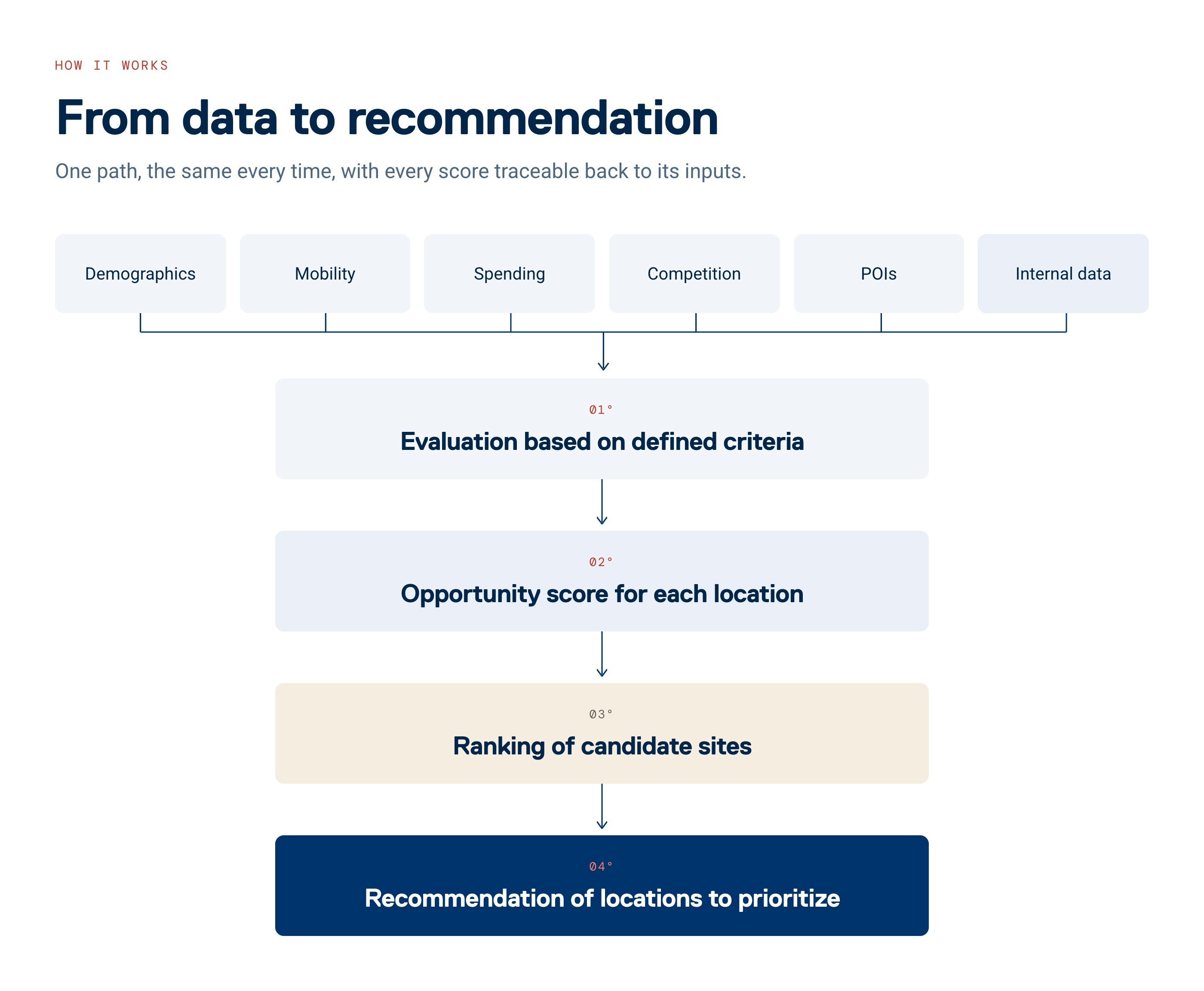
The key difference is therefore not whether the product includes a map. It is what you get at the end of the process.
GIS vs. BI vs. Location Data vs. Decision Platform
The following comparison shows the typical strengths of each approach from a business decision-making perspective.
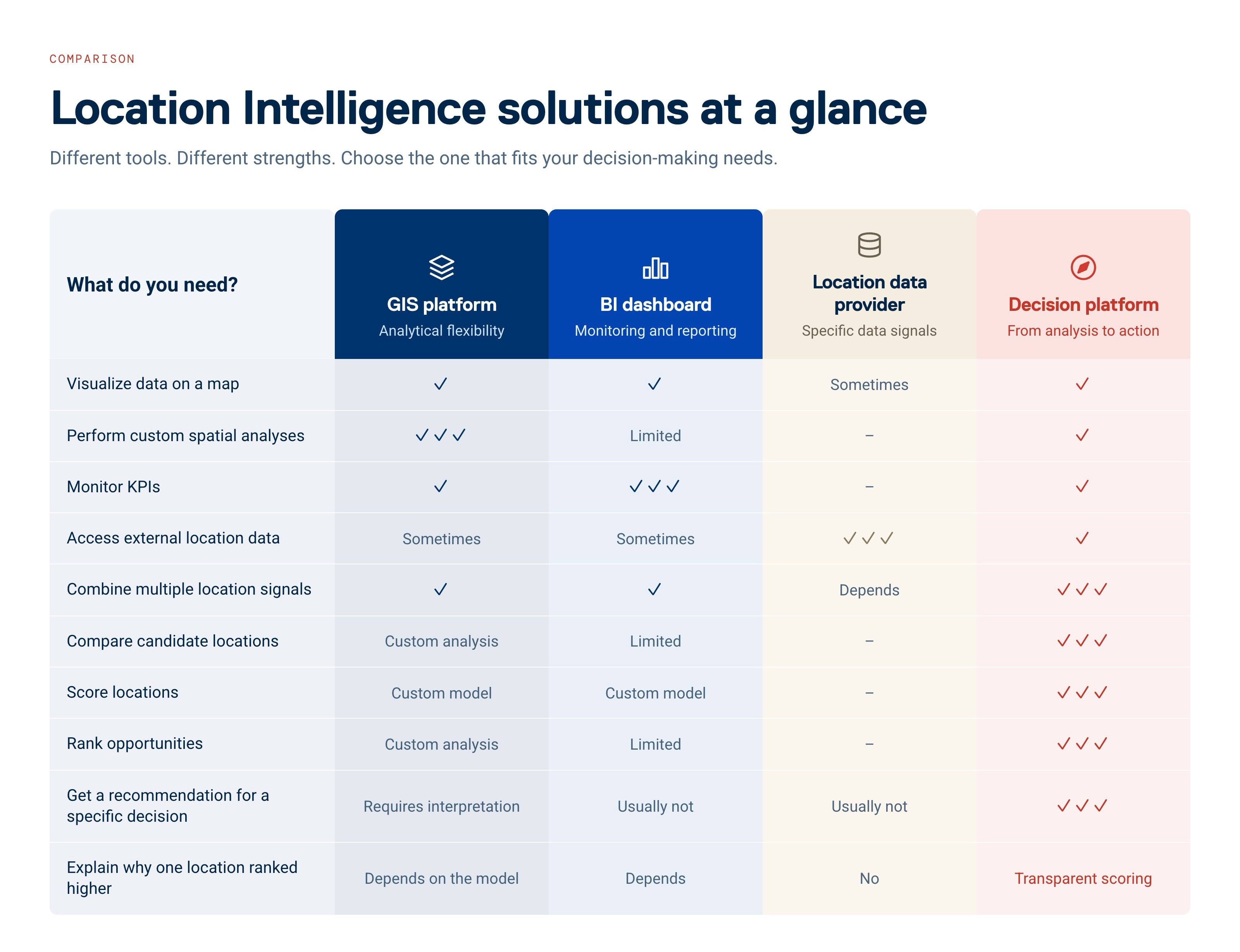
This table describes the typical focus of each category, not the absolute capabilities of every product on the market.
How to Choose a Location Intelligence Solution
Do not start by asking: "What features does the product have?" Start with the following questions instead.
1. What decision are you trying to improve?
For example:
store network expansion,
site selection,
parcel locker placement,
branch and ATM optimization,
site evaluation for investment or development,
identification of untapped market potential.
The more precisely you can define the decision, the easier it becomes to choose the right technology.
2. Do you need analysis or a recommendation?
This may be the most important question. If you want analysts to explore data freely and investigate different spatial relationships, you need an analytical tool.
If you repeatedly need to answer "Which location should we choose, and why?", you need a solution built around a decision workflow.
3. Who will use the solution?
A GIS specialist and an Expansion Manager have very different requirements. Ask yourself: Does a GIS analyst need to sit between the business user and the answer?
If the answer is yes and that fits your organization, a traditional GIS platform may be the right choice.
If commercial, expansion, strategy, or network planning teams need to work directly with the results, the clarity and usability of the outputs become much more important.
4. What data goes into the decision?
A single data layer rarely describes the full commercial potential of a location. Depending on the use case, relevant signals might include:
Demographics + Mobility + Spending + POIs + Competition + Internal business data
The important question is therefore not simply how much data a platform provides. It is how those data signals are connected to the decision you need to make.
5. Can you explain the result?
"AI recommended Location B" is unlikely to be a convincing argument for a significant investment. When a location decision involves capex, a long-term lease, a property acquisition, or a major network change, teams need to understand: Why did this location receive its score? Which factors influenced the result? Why is one option stronger than another?
Transparent methodology is therefore an important part of a trustworthy Location Intelligence solution.
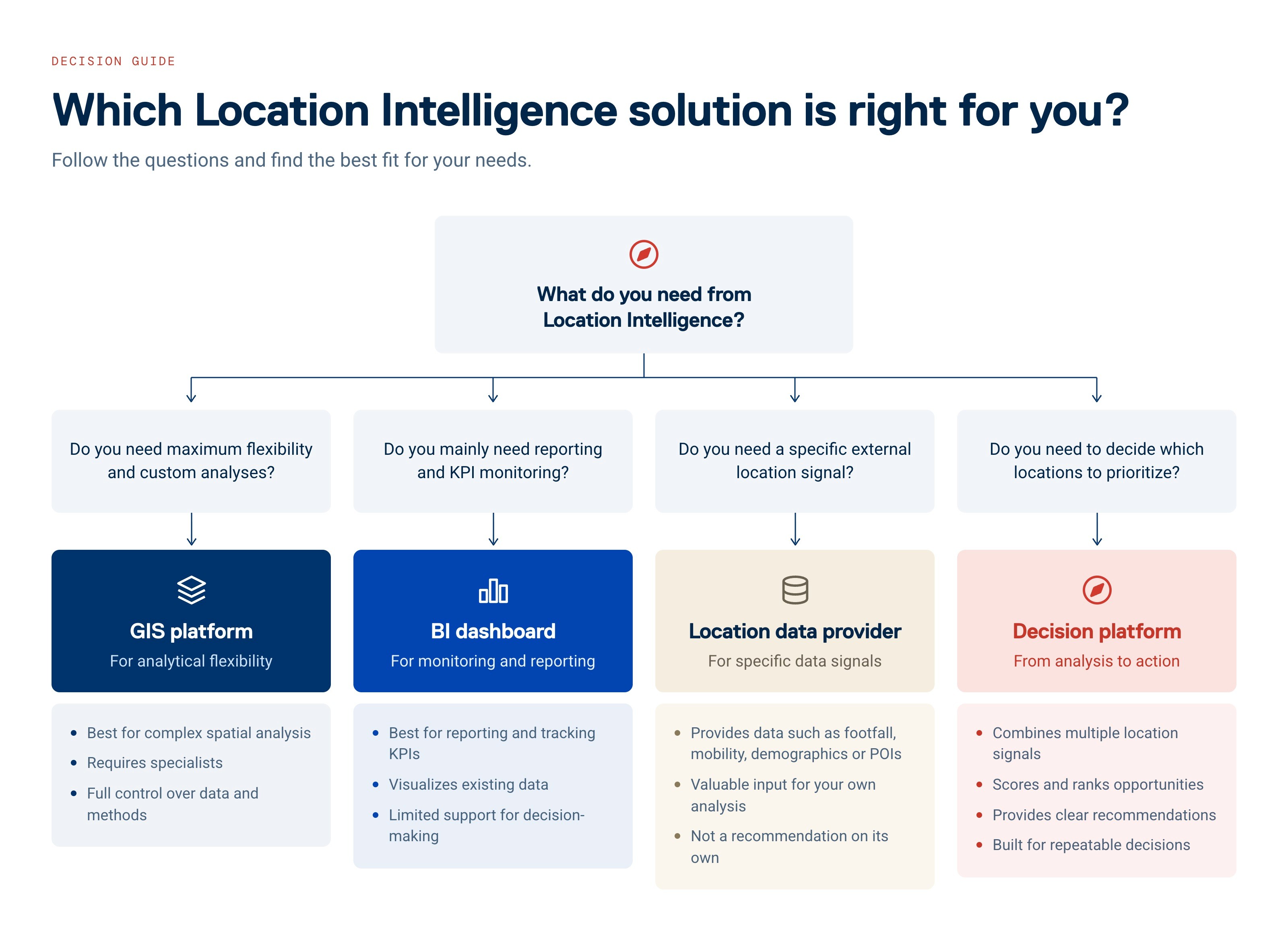
A Simple Location Intelligence Decision Tree
What do you need from Location Intelligence? Answer the questions below to find the solution that best fits your needs.
When Does CleverMaps Make Sense?
CleverMaps is particularly relevant when location directly affects a commercial decision and your organization needs to make those decisions repeatedly and consistently.
Typical use cases include:
Retail: Where should we open our next store? Which candidate locations have the highest business potential? Which areas should we avoid?
Logistics: Where should we place a parcel locker or service point? Where do demand, accessibility, and network value come together?
Banking: Where does a branch or ATM make sense? Where are the most important gaps between current coverage and local market potential?
Real estate and development: Does a candidate site have sufficient market potential? Which weaker locations can we reject before committing significant capital?
In practice, these use cases include store network expansion, asset placement and network planning, branch and ATM optimization, and site evaluation for development and investment.
When Might CleverMaps Not Be the Right Choice?
If your primary requirement is general-purpose geospatial infrastructure, custom spatial application development, or a highly flexible GIS environment for specialists, a full GIS platform may be a better fit.
If you only need regular reporting of a few KPIs on a map, a BI solution may be sufficient.
And if you already have an experienced location science team and simply need access to a particular dataset, buying that data directly may be the more efficient approach.
A good Location Intelligence solution is not the one with the longest feature list. It is the one that fits your decision-making process.
Don't Choose a Map. Choose How You Want to Make Decisions.
GIS platforms, BI dashboards, location data providers, and decision platforms can all be the right choice.
But they solve different parts of the problem.
GIS gives you tools for analysis.
BI helps you monitor what is happening.
Data providers give you market signals.
Decision platforms help you determine what to do next.
That final step is why CleverMaps is built for decisions, not just analysis.
Instead of stopping at another map or dashboard, CleverMaps connects relevant location data with transparent decision logic and practical outputs that teams can use in real business processes:
Ranked opportunities → Scorecards → Comparison → Recommendation → Decision
Which approach fits your use case?
Look at the location decisions your team currently makes using spreadsheets, dashboards, and maps.
If the analytical process still ends with another meeting where the actual decision has to be worked out, you may not need another analytical tool. You may need to bring the analysis closer to the decision.
Frequently Asked Questions About Location Intelligence Solutions
What is Location Intelligence?
Location Intelligence is the use of geospatial and business data to understand how location affects business performance and opportunities. It can include map visualization, spatial analysis, data enrichment, location scoring, site comparison, and decision support.
What is the difference between GIS and Location Intelligence?
GIS is primarily a technology for managing, analyzing, and visualizing geographic data. Location Intelligence is a broader business approach that uses location data and spatial context to answer commercial questions and support decisions.
What is the difference between Location Intelligence and Business Intelligence?
Business Intelligence typically focuses on reporting and analyzing business performance data. Location Intelligence adds spatial context, helping businesses understand where customers, competitors, demand, assets, and opportunities are located.
Decision-oriented Location Intelligence goes one step further by using this context to compare, score, and prioritize specific opportunities.
Do you need a GIS specialist to use Location Intelligence?
Not necessarily. Traditional GIS often requires specialist expertise. Decision-oriented Location Intelligence solutions can structure the analytical logic and outputs so that commercial and strategy teams can work directly with the results.
What data is used in Location Intelligence?
The right data depends on the business decision. Relevant inputs can include demographics, human mobility, consumer spending, points of interest, competition, accessibility, and internal company data.
The value comes not only from having these datasets, but from combining them in a way that is relevant to the decision.
How do you evaluate a Location Intelligence platform?
Do not evaluate a platform only by the number of datasets or features it offers. Ask six questions:
What specific business decision does it help us make?
What data does it use?
How is that data evaluated?
Do we get only a map, or also scoring and rankings?
Can we explain the recommendation to management and other stakeholders?
Can we apply the same methodology consistently across future decisions?
Is AI important when choosing a Location Intelligence solution?
AI can make analysis and interaction with software easier, but AI alone should not determine which platform you choose.
For significant location decisions, data quality, relevant decision logic, transparent methodology, and usable outputs are more important than an AI label.
What is the best Location Intelligence software for site selection?
There is no single best Location Intelligence solution for every site selection use case. GIS platforms are well suited to custom spatial analysis, data providers supply individual market signals, and decision platforms are designed to compare, score, and rank candidate locations. The right choice depends on whether you need data, analysis, or a recommendation.